Click the map's Google logo to go to Google Maps - for Directions, Street View etc.
Getting ThereOpen Cycle Map Bing Map
Nearest rail station Elgin (ELG) has level access to both platforms (for Platform 2 use New Elgin Road bridge heading for Rothes (A941), right at roundabout into Edgar Road, then 1st right adjacent to Asda car park) and now has a new footbridge with lifts not shown on station plan as yet. Live train times: ELG What remains of Spynie is accessed by a minor road off Linksfield Road on the outskirts of Elgin. A farm track leads frm there to the road that leads from the main Lossiemouth Elgin Road (A941) to Spynie Palace. Another farm track leads to the Elgin - Lossiemouth Railway Path. Spynie and WhiskyMisako Udo mentions a lost distillery at Hill of Spynie, from "date unknown to 1795". Nowadays head for Elgin which is home to world famous Whisky retailers Gordon & MacPhail, and the nearest distilleries:
Spynie Kirk and ChurchyardThe site of the old church (cathedral) is comemmorated by a plaque in the Churchyard, but the parish church itself was moved several miles to a site NW of Elgin now known as Quarrywood in 1738. A history of the Kirk is provided on the Duffus Parish website.
CyclingBikes Revolution 15 Shore Street, Lossiemouth 01343 610864
Bike Hire and Repairs (Mon-Fri). Also sell refurbished bikes. Bikespokes Mobile Repairs 07801 365710 @ Van based mobile servicing & repairs - normally 25 miles radius from Forres, but will travel further for an extra charge Bikes and Bowls 7 High Street, Elgin 01343 549656 The Elgin and Lossiemouth RailwayBy the time the Morayshire Railway, as it was initially known, was buit in 18?? Spynie was no longer important enough to warrant a station, but the track of the railway passes close to the ruin of Spynie Palace.
|
Spynie is a now insignificant place between Elgin and Lossiemouth which once had a much more important role in the area, as can be gathered from it having a ruined Palace. Once Spynie ceased to be a harbour the settlement declined.
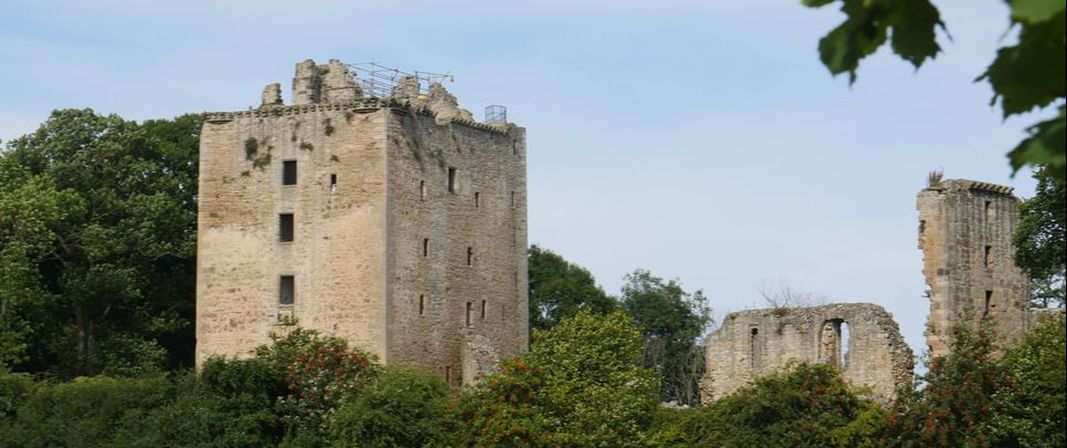
Spynie PalaceSo why does Spynie have a (ruined) Palace?.
The Palace, (originally known as Spynie Castle) was a relic of Spynie being the seat of the local Bishops of Moray, and Spynie's church was a Cathedral from around 1207 until the establishment of Elgin Cathedral in 1224, Elgin being considered a safer location due to the presence of a Royal Castle in the town. The Bishops of Moray continued to reside in Spynie Palace until 1682. The location was originally chosen because it was on the edge of Loch Spynie (see below), and Spynie was the harbour for Elgin until about 1500. Historic Scotland site. Wikipedia Loch Spynie and the Spynie CanalHistorically the River Lossie drained into this sea loch. From the descriptions I've read it may have been something like Findhorn Bay. The Findhorn is a bigger, faster flowing river than the Lossie, which may go some way to explain why it's kept its "sea loch". The Lossie meanders slowly around and through Elgin thence on towards Lossiemouth.
1000 years ago Loch Spynie would have spread inland at least as far as the hill upon which Duffus Castle was later built. Kintrae slightly further west could be from Celtic words meaning 'top of the tide'. Hector Boece suggests it was five miles in length. Ponts Maps of Scotland (c 1583-1614) shows the extent of the "Loch of Spyny" at that time. There may even have been a shallow channel making Burghead to Lossiemouth an island. Some sites (and this strange "map" on the Hopeman History site) even suggest that the name Roseisle is evidence of this, but the earliest maps I have been able to trace spell the name as Rossyll (1586?) or Rosyll (1654) - and it seems unlikely that the English form "isle" would have been used historically - more likely "inch" or the original Gaelic "innis". The maps mentioned above also show a separate inlet near to Rosyll. (Roseisle News provides some other interesting suggestions for derivation of place names in the area). The Loch began to silt up and ultimately due to storms was cut off from the sea. Efforts were then made to drain it and reclaim the land for agricultural use. The River Lossie may have entered the Loch between Caysbriggs (Kays Bridge) and Inchbroom, where the modern river makes a sharp right turn, which may have been artificial to keep the river and loch apart. The map of 1783 shows a still extensive Loch with a ferry at Saltor Hill, the Old Castle of Spynie on its southern banks, but no longer having an outlet to the sea, other than the New Drain and New Canal. The Spynie Canal which drained much of the Loch was built to a plan by Thomas Telford in 1808-11, but the area was again flooded after a storm in 1829. In 1860 the Canal was restored and deepened and better sluice gates added to the outflow in Lossiemouth. A small portion of the Loch remains. The canal has many other drains feeding it and extends at least to Duffus, Waterton and Kintrae. |
Photos on this page were taken by me. Click on photo to enlarge. Full size versions and my other pictures of Spynie are available at:
https://www.flickr.com/photos/martynjenkins/sets/72157686000614710
https://www.flickr.com/photos/martynjenkins/sets/72157686000614710
