The origin of the name Dumfries is not known for sure. Dum, dun and drum are common Scottish place names deriving from hill or fort (or both), and the second part of the name may come from "Phreas" or "Phris" meaning copse or thicket. Earlier spellings of D(o)unfres, Drumfrees and Drumfreiss have been recorded, which have lead to suggestions that it could have derived from "fort of the Frisians" - a Germanic race. Another suggestion has been that it is from hill of the Friars.
Nearby: Troqueer; Kingholm Quay; Glencaple; Caerlaverock; Lincluden; New Abbey; Locharbriggs.
Undiscovered Scotland dumfries-and-galloway.co.uk/ wikipedia
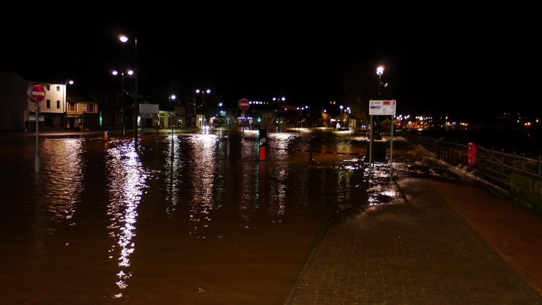
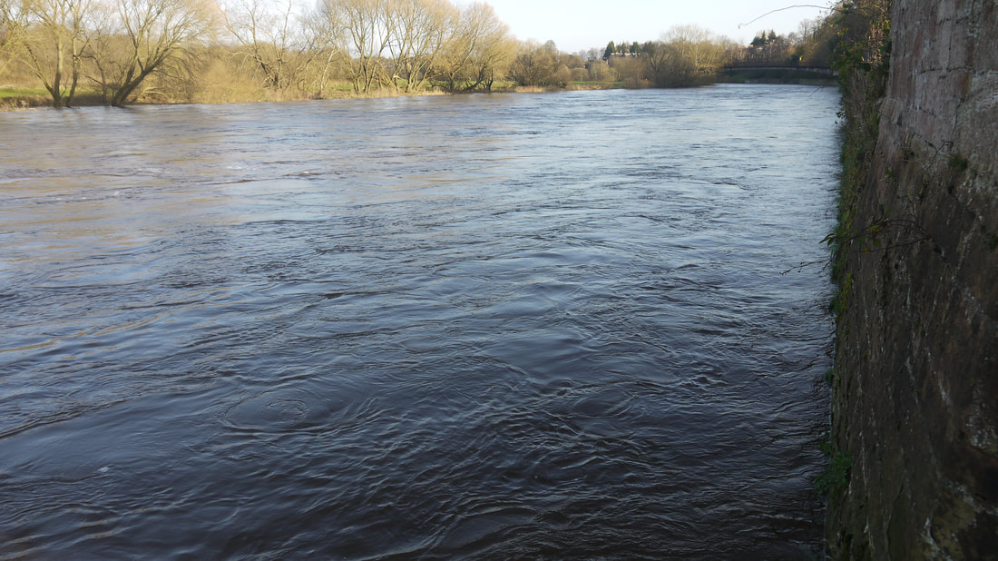
Dumfries lies on the River Nith, Scotland's seventh longest river, it is tidal and navigable as far as the town, which allowed it to become a port. Dumfries also remains the first bridging point of the Nith, though the newest bridge is a mile south of the Devorgilla Bridge the first to be built. The old bridge was superseded by the Buccleuch Street Bridge in 1793 slightly to its north, and supplemented by the St Michael's Bridge in 1925. The pedestrian suspension bridge between them had come in 1875. Prior to the construction of the old Auldgirth Bridge in 1782 (7 miles from Dumfries), the Devorgilla was the only bridge over the Nith for a long way - though the Nith Bridge (14 miles) near Thornhill was built in 1777, it is said there was a wooden bridge there from the 1400s until swept away some 200 years later. Earlier than that there were apparently older bridges at Drumlanrig (17 miles) which is said to have been repaired in 1710 - "the repairs were necessitated by the timber foundations of that part having been washed away some 40 years earlier"; and at Eliock (24 miles), near Sanquhar, while dated to 1696, however, Scotland's Oldest Bridges quotes: "Sanquar parish records in 1661 note that Parliament sanctioned the raising of funds from all parishes for the rebuilding of the bridge at Sanquar." The Devorgilla Bridge was built around 1270 by the Lady Devorgilla, whose husband Sir John Balliol founded Balliol College, Oxford, and whose son John Balliol was to become King of Scotland in 1292. The current bridge dates from around 1621, but still bears the Devorgilla name, and parts are thought to have been from earlier bridges on the same site. When built it had a further three arches over what is now Whitesands. Just to the south of the bridge is a weir known as The Caul, which dates from the early 1700s and was built to help prevent erosion of the east riverbank. Flooding has been a regular problem and work is now being undertaken to build flood defences in Whitesands and Dock Park. The River Nith also has a tidal bore - minimal compared with that of the Severn, but one of less than 20 in the UK. Maps: 1654 with West at top 1819 1850 showing original Station where Morrisons is now 1856 
Nith Bore at Kingholm Quay, 2 miles south of Dumfries
Dumfries & WhiskyDumfries has no Distilleries, now but Misako Udo has records of a Dumfries Distillery operating from 1795-1826, sited in Buccleuch St, producing 27000 litres a year towards the end of its life. There was also a Maxwelltown Distillery, only known to be operational in 1818-1819, but in both cases, there may have been earlier unlicensed activity.
Dumfries does have a Whisky Shop - TB Watson, home of the Drambusters, organisers of frequent tastings and since 2011 a Festival. A number of bars with reasonable range of malt whiskies - see under Drinking. On my first visit in November 2011 to attend the Drambusters Festival and found the town to be a very friendly place. Brian at TB Watson suggested 3 possible Whisky Bars, and the Tam O' Shanter sounded most interesting. I also enquired about food at the Tourist Office and was told that there was an Italiano-Thai restaurant in town - turned out to be in the same building as the Tam O' Shanter (the restaurant has subsequently closed). Nearest Distilleries: Bladnoch (50 miles), and Annandale (16 miles) which has recently been rebuilt and has produced some very promising new make spirit called Rascally Liquor - whisky expected Spring 2018. 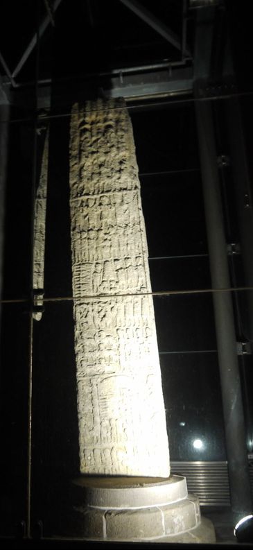
Devorgilla Bridge and the Caul
Local BeersSulwath Brewery in Castle Douglas is highly recommended by WhiskyCyclist - their beers available in Dumfries and surrounding area, and other parts of the country.
NearbyTroqueer ("farmstead on the river-bend", from Cumbric, an ancient Celtic language related to Welsh, spelt "Tracuyir" on the 1654 map) and Maxwelltown on the west bank of the Nith were originally within Kirkcudbrightshire - part of Galloway (the name comes from "Gall-Ghàidhealaibh" - "stranger Gaels" - the area had been settled by Vikings, as well as Gaels ). Connected to Castledykes Park, Dumfries by the Kirkpatrick Macmillan Footbridge, named after the inventor of the bicycle.
Troqueer also includes an area outside the town - Mabie Forest 7stanes mountain biking centre and the settlements of Cargenbridge and Isleteps. Troqueer Arms* 152 Troqueer Road 01387 254518 MW Kingholm Quay a small settlement on the outskirts of Dumfries, and now as far as most shipping can proceed up the River Nith. The Quay is home to Tall Ship La Malouine, a twin masted French Brigantine. The Swan* Kingholm Road 01387 253756 RA Glencaple, 5 miles south of Dumfries has a quay which was established in 1746, and at one time had a passenger service to and from Liverpool. Nith Hotel Glencaple 01387 770213 Caerlaverock Tea Room Quayside, Glencaple 01387 770673 Caerlaverock Castle "lark castle" is a ruined moated triangular castle about 7 miles south of Dumfries. The foundations of an earlier castle are about 200 yards south of the castle that was built in 13th century - it was besieged during the Wars of Scottish Independence and was partially demolished and rebuilt several times over the next 400 years until its abandonment in 1640 following a siege by the Protestant Covenanter army. Historic Scotland now look after the castle, which is open to the public all year round. Caerlaverock National Nature Reserve was set up by the Duke of Norfolk in the 1950s. It has been run by Scottish Natural Heritage for the Caerlaverock Estate since 1957. Next to the NNR is the Caerlaverock Wetland Centre which has a 15% reduction on admission price if you arrive by bike. The nearby village of Bankend is so named as it marks the end of the ridge that separates the River Nith from the Lochar Water. Hutton Lodge Bankend 01387 770216 New Abbey is a small village 6 miles from Dumfries (Undiscovered Scotland), nestling under Criffel, the prominent hill in the area. It takes its name from Sweetheart Abbey, the ruins of which dominate the village. It was founded by Devorgilla (see above) in 1275 in memory of her husband, whose heart she had embalmed (after his death) and she carried with her for the rest of her life (romantic or creepy, maybe both). While Devorgilla named the abbey Dulce Cor (sweetheart), the first abbot renamed it New Abbey of Pow (as it was newer than its mother abbey Dundrennan, near Kircudbright). Undiscovered Scotland. The Abbey is now under the care of Historic Scotland. Abbey Arms Hotel 1 The Square 01387 850489 RA (The Criffel Inn shown on Undiscovered Scotland page is closed) Newbridge is a small settlement 2 miles from Dumfries - the bridge in question is across the Cluden Water, and dates to 1758, though widened in the 20th century, it has long since been by-passed by the current bridge carrying the A76. To the North is the stone circle known as the Twelve Apostles - watch out for cows (see slideshow below)! The Ancient Scotland website has a picture of the hedge that used to divide the stone circle. Other web pages relating to the Twelve Apostles: Canmore Undiscovered Scotland The Megalithic Portal Woodland House Hotel New Bridge 01387 720233 Lincluden Collegiate Church is on the outskirts of Dumfries close to the confluence of the Cluden Water with the River Nith - another Historic Scotland ruin. Martinton ford used to cross the Nith on the other side of the Cluden to Nunholm, a considerable shortcut! Nunholm is now beset with bridges, though only accessible from the Queen of the South, former railway bridge. A lot of the Burns Walk alongside the Nith around Nunholm can be cycled, but the extension into Dumfries past the Academy is narrow and can be slippery, with no protection from the Nith one side and a wall the other - it's also low and prone to flooding. Locharbriggs ("loch àird brig" - bridge near loch of the height") stood on the edge of the Lochar Moss, which surrounded the Lochar Water from here to Bankend until it was drained in the 19th century. The drainage was the first civil engineering project of John Smeaton. The extent of Lochar Moss is shown in 1807 map. Locharbriggs had a station on the Dumfries, Lochmaben and Lockerbie line, opened in 1863, but closed to passengers in 1952 and completely in 1966 - the section from Dumfries to Locharbriggs is now a cyclepath. North of Locharbriggs the line has been obstructed by quarrying - Locharbriggs having been a source of red sandstone, particularly for buildings in Dumfries, Glasgow and Edinburgh. Southpark House Quarry Road 01387 711188 The Lochar Inn Edinburgh Road, Heathhall 01387 254159 Tinwald is a tiny settlement just North of Locharbriggs, but also the name of a former parish North and NE of Dumfries, from the Manse of Tinwald near the A701 to East Tinwald by the A709. To the south what is now Heathhall Industrial Estate and the Dumfries & Galloway Air Museum, was previously known as Tinwald Downs, and RAF Dumfries during WWII. The name is of Norse origin meaning "assembly or "parliament" (like Tingwall, Shetland; Dingwall or Isle of Man parliament - Tynwald). Torthorwald another former parish with a name of Norse origin meaning "tower of Thor in the wood". A small village East of Dumfries with a ruined castle and a restored cruck-framed cottage - the last example of what was a common type of cottage in this area (damaged by fire, believed to be arson, 9/1/18) . Manor Country Hotel & Restaurant Lockerbie Road 01387 750555 MW RA Lockards Farm Pub Lockerbie Road 01387 261618 RA 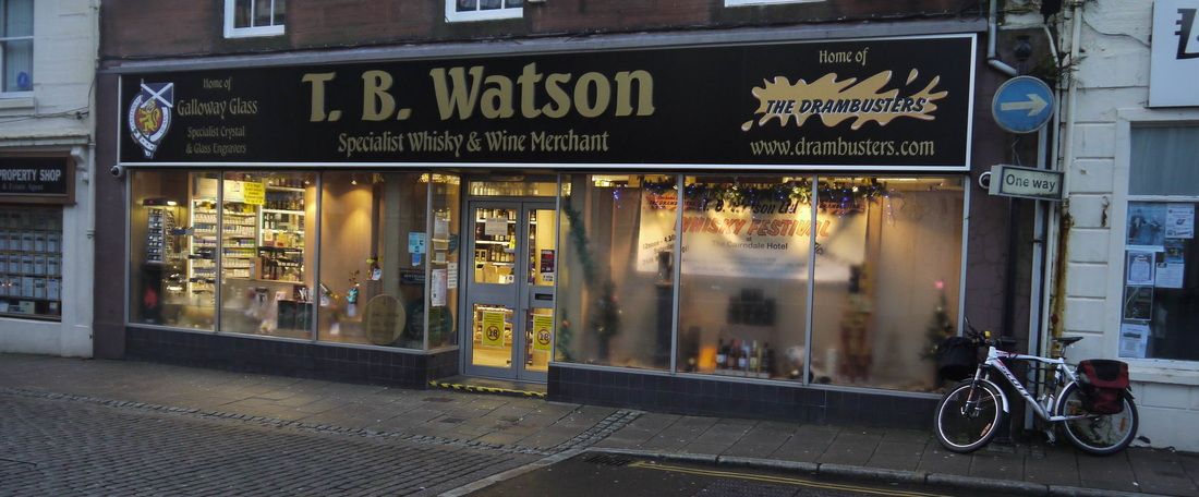
|
Dumfries became a Royal Burgh in 1186, and was the scene of a number of incidents in the conflict with English invaders - William Wallace is recorded as chasing a retreating English force through Dumfries after the Battle of Stirling Bridge (1297). In 1300 English King Edward I invaded Scotland, but signed a truce in Dumfries following the intervention of the Pope.
Robert the Bruce established his claim to the throne of Scotland by murdering his main rival John Comyn (or "slew the traitor Cumin") at the altar of Greyfriars Kirk in Dumfries in 1306. Though excommunicated for this, The Bruce was crowned King shortly afterwards. Bonnie Prince Charlie held court in Dumfries for 3 days in 1745, but the most famous resident of the town from 1791 until his death in 1796 was Robert Burns. Inhabitants of Dumfries are known as Doonhamers (as are the local football team Queen of the South), as they were apparently in the habit of telling folks from further north "am gan doon hame". The Queen of the South FC website gives the following as the origin of the name: "Dumfries had been nicknamed 'Queen of the South' by David Dunbar, a local poet, who in 1857 stood for Parliament in the General Election. In one of his addresses, he called Dumfries, 'Queen of the South', and this became synonymous with the town." The same site explains the origin of the town and club motto: "The club badge contains the same motto as that on the crest for the town of Dumfries, 'A Lore Burne', meaning, 'To the Lore Burne', (the historical rallying point in Dumfries against outside attack)." The Lore (muddy) Burn is a long-culverted stream under Dumfries, the Dumfries Museum site has this: "Its source was a deep bog in Catherine Street and it ran southwards parallel with Loreburn Street. It turned to the east after crossing English Street and joined the Millburn on the east of Queen Street. The Millburn ... crossed Queen Street and flowed on through the gasworks to behind Clerkhill ... Finally it crossed St Michael's Street and entered the river. Nowadays it runs underground and its culverts can be seen in the river wall beside the Suspension Bridge." Arriving & DepartingOpen Cycle Map Bing Map
Dumfries is on National Cycle Route 7 and has many local cycle routes. Dumfries (DMF) rail station has level access to both platforms (Platform 1 from Station Road off Lovers Walk, Platform 2 across road bridge, St Mary's Street, and down path) with irregular trains to Glasgow & Kilmarnock, a few more to Carlisle - some of which go on to Newcastle. Despite some much trumpeted (by ScotRail) improvements, there are still unacceptably lengthy gaps in the timetable. On Sundays the service is frankly disgraceful only 2 trains each way between Dumfries and Glasgow - and only 5 to and from Carlisle. Live train times Once upon a time, Dumfries was a major railway hub, with trains to and from London, Stranraer, Lockerbie, Kirkudbright (and a strange little branch line to Moniaive), as well as Glasgow and Carlisle. The most ridiculous closure was the direct line to Stranraer, at the time of the infamous Beeching Report. At the time there were still boat trains from London to the (then) Stranraer Ferry, and these continued after the closure though diverted via Mauchline - adding 50 miles to the route. {Though as argued here, the route of the original line didn't help its case}. SleepingFerintosh GH* 30 Lovers Walk 01387 252262 @
Right opposite the Station. Biscuits, Mint chocolates and a dram of Malt Whisky to welcome you! There's also a welcome pack in the room with masses of info about Dumfries. Great accommodation and breakfast. Ferintosh has an extensive and informative website. The name of the Guest House is also Whisky-related as described on the website. Langlands* 8 Edinburgh Rd 01387 266549 @ Stayed there when Ferintosh full in 2014, friendly, hospitable, good value. Bike can be accommodated in cellar. Torbay Lodge* 31 Lovers Walk Now seems to have closed Stayed there when Ferintosh full in 2013. Dumfries Villa 33 Lovers Walk 01387 248609 @ Not stayed at this GH, which is in the same building as Torbay Lodge above. Morton Villa B&B* 28 Lovers Walk 01387 255825 Opposite the station For other accommodation - see the Undiscovered Scotland Hotels & Inns and Guest Houses and B&Bs pages and dgvisitor.co.uk EatingCavens Arms* 20 Buccleuch Street 01387 252896
Can get very busy - great food - and drink (see below). Ivanos* 11 Whitesands 01387 253453 Italian takeaway, where I had the best Fish Supper I've ever had. OK it was after the Drambuster's festival, which was probably why I went back in there and told them it was the best ever! Visited again when sober - still good, and the Haggis Lasagne sounds interesting too. Pearl Palace* 17 Castle St 01387 250504 Special Sizzling Chicken with Garlic and Spring Onions in November 2017 - again after the Whisky Festival, an excellent way to sober up. Have eaten there before, so it wasn't just the whisky! Royal India* 46 Buccleuch St 01387 266644 The Pleuchie's Howff * 97 Annan Road 01387 268 704 Couple of real ales, and an interesting menu, including their signature dish Lomo Saltado Peruvian stir fry style dish using strips of beef, potatoes, yellow peppers, spices and seasoning. (July 2016: restaurant no longer open). 
Tam O'Shanter Inn
Tam O'Shanter Inn
DrinkingCavens Arms* 20 Buccleuch Street 01387 252896 40 RA
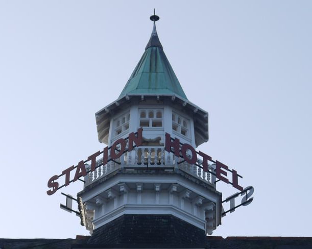
Around 40 Malt whiskies and 7 different real ales - Beerbat - try 3 ales for the price of a pint! New Bazaar* 39 White Sands 01387 268776 60 RA Largest selection of malts in Dumfries, including some bottles that may have been open too long, but you're unlikely to see them elsewhere. Tam O' Shanter* 113-117 Queensberry Street 07855 473933 20 RA Expanding its range of Malt Whiskies. Robert the Bruce* Buccleuch Street 01387 270320 MW RA Wetherspoons pub in former Methodist church. Other bars with range of Malts: Coach & Horses Inn* MW RA, Station Hotel MW, Waverley Bar* MW Station Hotel MW and The Globe Inn* 50 RA. Many of the above links are to pages on the CAMRA What Pub? site. CyclingG&G Cycle Centre Dumfries* 10-12 Academy Street 01387 259483
Kirkpatrick's Cycles 13-15 Queen Street Closed September 2014 DG2 Wheels 12 Terregles Street 01387 256808 SolwayCycles 86 – 88 Annan Road 01387 252217 Opened June 2016 Halfords St. Michaels Bridge Road 01387 267118 Bike2go Dumfries had an automated bike hire system with 12 locations where bikes could be hired but it is currently mothballed.
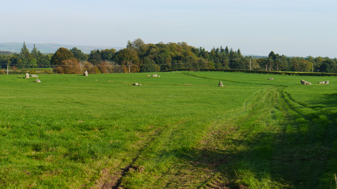
The Twelve Apostles Stone Circle
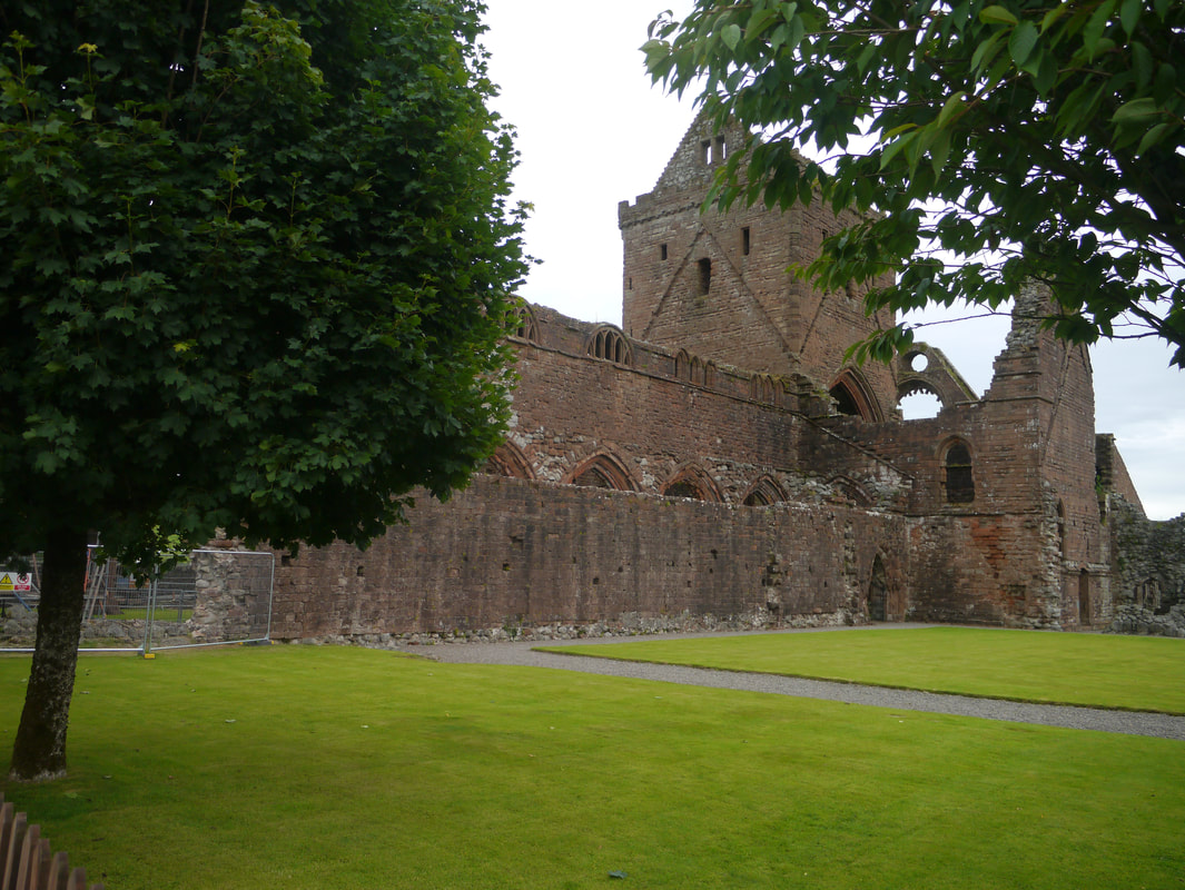
Sweetheart Abbey
|


Photos on this page were taken by me. Click on photo to enlarge. Full size versions of these and my other pictures are available o Flickr - Dumfries: http://www.flickr.com/photos/martynjenkins/sets/72157629551673513
Newbridge: https://www.flickr.com/photos/martynjenkins/albums/72157662222101987
New Abbey: https://www.flickr.com/photos/martynjenkins/sets/72157662370293657
Caerlaverock: https://www.flickr.com/photos/martynjenkins/sets/72157691184061754
Kingholm Quay: https://www.flickr.com/photos/martynjenkins/sets/72157691184327064
Glencaple: https://www.flickr.com/photos/martynjenkins/sets/72157664413351168
Locharbriggs: https://www.flickr.com/photos/martynjenkins/sets/72157662371277787
Twelve Apostles Stone Circle: https://www.flickr.com/photos/martynjenkins/sets/72157662219911907
