Campbeltown's Lost Distilleries D-K
For details on the maps linked to, see main Campbeltown's Lost Distilleries page.
dalaruan
There were two distileries with frontage on Dalaruan Street, but not Dalaruan - it was one of three distilleries on either side of Broad Street. As mentioned on the main Campbeltown page, Campbeltown was originally known as Dalruadhain an early capital of the Dalriadan kingdom - Dalaruan is pronounced the same as the older spelling, but is easier to read! Dalaruan was on the corner of Broad Street and Lady Mary Row.
Barnard reports that "Peat only is used in drying the malt"; the distillery had three pot stills; and two wells on site, used mainly for reducing the spirit. 1885 output: 112,000 gallons.
Nothing is now left of Dalaruan - Lady Mary Row has now been extended through it's former premises, and the distillery was replaced in 1938 with a housing development called Parliament Place (see picture on Lost Distilleries site). This development has now been replaced by New Parliament Place, but the road appears to still bear the name of Broad Street (despite Google Maps having appeared to name it after the housing development).
From David Stirk's book, Appendix B, a letter dated 23rd October 1919 says "Dalaruan is not working yet, but they intend to this season". It seems likely that it did re-start production, but not for long, and by 1925 was put up for sale for £15,000 - in relating this sale, David Stirk says year unknown, but the Lost Distillery Company has it as from The Scotsman dated 26th March 1925. Whenever the sale took place, it was the stock of whisky that was of more interest than the distillery itself, which indeed never worked again.
Maps: 1865 shows the lade which would have supplied water to the distillery and the three differently sized worm tubs; 1898 just labelled distillery; 1898(6) not labelled 1938 with housing development labelled Parliament Place; 1959 Google Site of Distillery
History of Dalaruan from the Lost Distillery Company, who are seeking to recreate the Dalaruan malt.
dalintober
|
Dalintober Distillery moved. It is shown on the Town Plan of 1865 as a small premises on the north side of Queen Street. Barnard however, says "The Distillery buildings cover nearly two acres of ground, and have a frontage to Kinloch Park of five hundred feet, hence they command the finest view of any of the Distilleries, which includes the town, mountains and bay".
If we are to believe Barnard, and why wouldn't we, we have to move the location to John Street, which allows for a 500 foot frontage on Kinloch Park.But where does that leave Lochraun. From the 1865 map, North Shore Street ran along the then shore and ended at Prince's Street and the Lochruan Distillery. Later maps indicate that with the draining of Kinloch Park, John Street is extended alongside the Park to this point - but there is an offset between John Steet and North Shore Street, allowing an additional building in front of Lochruan. |
Barnard says that "about twenty years ago it came into the hands of the present proprietors, by whom it was extended and improved." 20 years before Barnard's visit, the Park had not been drained, so Lochraun's expansion cannot have been into this building then - and they do appear to have expanded with buildings filling in between the original distillery and Dalintober High Street. And Barnard also refers to Lochruan being "close to Kinloch Park" and commanding "a side view of the bay". The 1898 map shows a distillery fronting on (what will become) John Street, with two wormtubs towards the front of the site - the sketch of Dalintober in Barnard shows buildings appopriate to the 1898 map, and what could be two wormtubs in the correct position. Unhelpfully the 1898 map just labels the area Distilleries. However, I've now found a 1914 showing Dalintober (and Lochruan) in their new positions; a 1938 map showing the sites blank; and a 1959 map showing the new housing.
Barnard goes on to describle the distilling process in great detail for Dalintober, mentioning "peat fires". Three stills are used in the production, Barnard says "They are called Low Wines and Feints Stills and hold 1,073 and 1,066 gallons respectively. From these Stills the product again goes through condensing worms, emerging therefrom as a pure spirit." "Annual output in 1884-5 was 120,000 gallons." Misako Udo also gives a figure of 170,000, without stipulating a date.
The distillery finally closed down in 1925, however, David Stirk's book contains a substantial appendix detailing the Peter Dewar Letters. The intrduction says "In 1916 David Colville died and due to his inheritors not wanting to continue with the distillery in the same vein, put distillery manager Peter Dewar in charge of winding up the business and accounts." The letters reveal that Dalintober had not distilled since the "1913/14 season".
"In 1919 West Highand Malt Distilleries Ltd ... took over a number of Campbelton distilleries. These were Ardlussa, Dalintober, Glen Nevis, Glengyle and Kinloch."
Maps: 1865/1898 1898 1898(6) 1914 1938 1959 Google the walls may be relics of Dalintober (and/or Lochruan), nothing else seems to remain. (The buildings in the backgound are Glen Scotia Distillery). This view form Queen Street shows what's left of the original site of Dalintober.
drumore
|
Drumore has two entries in Misako Udo's book one for 1834-1837 and one unknown to 1847. Both are given an address of Baregreggan Road, which must be a misprint for Balegreggan Road, but what little is known about it seems to point further out along the A83 to Drumore Farm, and West Drumore Farm.
David Stirk also says that Drumore "was situated on the old illict site at Drumore Farm, just on the town limit on the road to Machrihanish" Drumore House and Nursery were on the municipal boundary, but on the Tarbert Road (A83), so I think this is an error. The illicit still at Drumore is listed in David Stirk's Appendix H as being at map ref NR706221, which is where I've put the pin on the map. |
1866 maps show West Drumore, but there is nothing on subsequent maps, though there is a building later labelled West Drumore Cottage shown in 1866 and currently. David Stirk says "Drumore Distillery was sitated at the Drumore Farm steading", and mentions a couple of Templeton brothers, one a farmer of West Drumore, as partners in the enterprise. He also mentions Mrs Mary Mitchell or Fulton, widow of Robert Fulton. While Misako Udo has Mary Mitchell as the founder of the first listed distillery, and Templeton, Fulton & Co as licensees of the second.
In the obituary of John Mitchell (of Springbank) in 1892, reference is made to his brother WIlliam Mitchell, Drumore becoming a partner with him at Springbank in 1828, they also had a sister named Mary - there is nothing to say whether this was the same Mary Mitchell - they are listed separately in the Index.
So there is little known about this distillery (or distilleries), what is published is contradictory. Brian Townsend's book simply refers to it as a distillery which "faded" before the 20th century.
What is generally agreed is that the firm Templeton, Fulton & Co was sequestrated and the distillery was sold in 1847.
David Stirk also says that "A local story goes that there was still some plant in existence in the 1990s."
Maps: 1866 1866(6) 1898 Google
Glen nevis
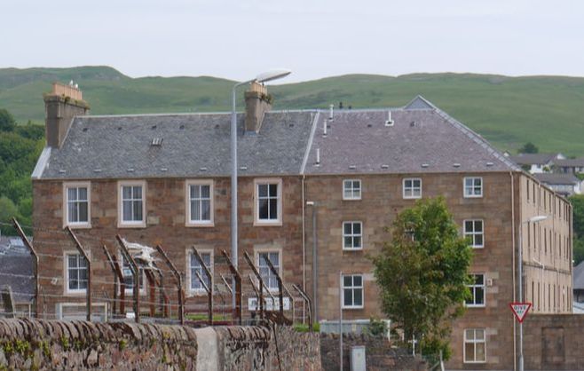
 Glen Nevis Warehouses in 2013
Glen Nevis Distillery was built in 1877, in the fairly new Glebe Street - opposite the rear of Rieclachan Distillery. It would soon be joined by Ardlussa next door to it - they were the last two distilleries to be built in Campbeltown. It was founded by Duncan MacCallum, who later, after selling Glen Nevis, briefly owned both Glen Scotia and Kinloch. See more on this enthusiastic cyclist under the Kinloch entry.
It was a young distillery when Barnard visited in 1885 - and he comments approvingly on its "commanding appearance" and that it "is both modern in style and arrangement, containing all the new improvements of the present day." Output at the time: 100,000 gallons.
Shortly after Barnard's visit MacCallum sold the Distillery to Scotch Whisky Distillers Ltd in 1887, but boughtit back from them two years later when the went bust. He sold it again in 1896 and in 1919 it fell into the hands of West Highland Malt Distilleries Ltd.
Production ceased by 1923, though the company kept going for another three years before being liquidated. Its warehouses and those of Ardlussa next door were converted in 1936 into a bottling and blending plant, though they had fallen into disuse by 1955, when the new owners of Glen Scotia Distillery, A Gillies & Co, bought them and again used them for bottling and blending. (Richard Paterson began his career there, and writes about it in his book Goodness Nose). By the 80s they were no longer in use and became derelict. They have since been largely razed and are used by McFadyen's Contractors as a yard. All that remains of Glen Nevis Distillery are the northernmost two warehouses and some walls
Maps: 1865 1866(6) 1898 1914 1938 1959 Google Remaining Glen Nevis warehouses
glengyle
|
Glengyle was built by WIlliam Mitchell, brother of Springbank's John (J&A Mitchell). In it's first incarnation it had a fairly short life, barely fifty years, but in 2000 the site was bought by J&A Mitchell, who re-opened it in 2004. Its late construction means that it is not present on the first two maps, which simply show a few houses north of Rieclachan distillery on Roading - Glebe Road and Glengyle Street do not yet exist. Indeed the Town Plan does not even extend to most of the site.
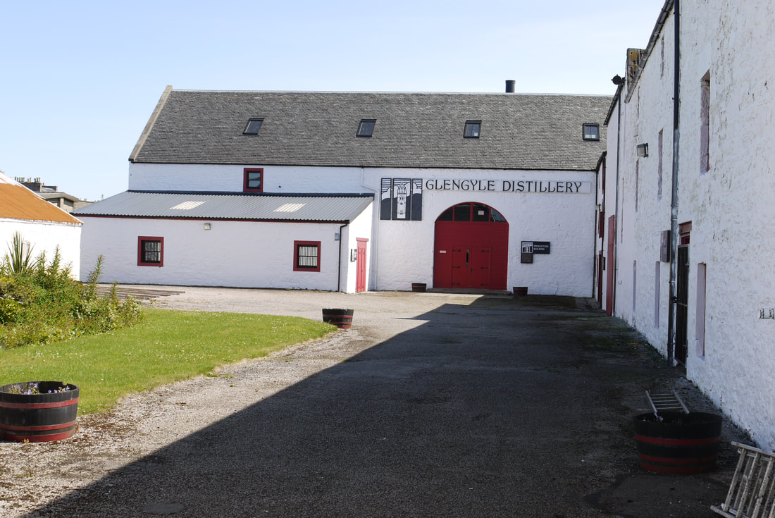
The re-opening by J&A Mitchell wasn't the first attempt to do so. In the 1940s the then owners of Glen Scotia (Blcoh Bros) bought the site, stock and brand and had plans to re-open that were thwarted by WWII. The site was subsequently sold and became a rifle range, but the brand remained in the ownership of Glen Scotia's owners, hence the need for a new name for the malt from Glengyle. For more on Glengyle - see main Glengyle page. Maps: 1865 1866(6)/1898 1898 1898(6) Picture shows Glengyle in 2009. |
|
Glenramskill
Glenramskill was another Distillery shortlived distillery in the 19th century that despite having been closed for some years before the first maps here, is still marked on the map. It is unusual in being both remote from the centre of town, and south of the town - almost as far as Davaar Island.
The exact dates of operation are not certain, but in 1835 the distillery was closed (Udo) and advertised for sale in Kay's Argyllshire Magazine (Stirk). Little more is know other than that it was finally closed in 1852.
The "beautiful garden" mentioned in lostdistillery.com (pic1, pic2) has given way to a junk yard by the look of the Google Street View image linked to below.
Maps: 1866 1866(6) 1898 no longer labelled as a distillery 1914 Google
GlenSide
Glenside was built on what is now shown as Mill Knowe, but was not named on many of the older maps. The 1892 map shows it has expanded out to the Dalaruan Road.
Barnard mentions that "the water is brought into the works by a conduit direct fromthe Aucholochie Loch at the back if the distillery, and there is a splendid well of water within the enclosure." He is less enthusiastic about other aspects of this 55 year old distillery "It is almost as old fashioned as its neighbours, both as regards its appearance and it internal arrangements" and concludes that "nothing short of pulling the place down and rebuilding it, could ever give it the appearance of a modern distillery." Despite this he includes an etching of the distillery. Annual output was 70,000 gallons.
Glenside avoided the consolidation into DCL or WHMD that preceded the demise of several of Campbeltown's distilleries, but it had not been in production for about 4 years when it went into voluntary liquidation on 18th Decemer 1930.
All that is left is the wall marking the western boundary of the dsitillery, the rest has been replaced with a housing development caled Glenside. The road alongside the former distillery, previously shown without a name, is named as Glenside on the 1938 and 1959 maps - but is now Mill Knowe.
Maps: 1865 1866(6) 1898 1898(6) 1914 1938 1959 Google Housing named after the distillery, and the wall that is all that remains.
Hazelburn
|
Hazelburn was the first distillery in Campbeltown that Barnard visited, and the one about which he gives the longest description.
Barnard states that "The Hazelburn Distillery was founded in the last century, and rebuilt in the year 1836. It is said to be planted on the site of the Parliament House, where James IV held a parliament when he emancipated the vassals of the McDonalds." David Stirk states "Said to have originally been situated c1825 '...in Longrow while the malt barns stood at the west end of what is now known as Longrow South.' ... Increased buisness meant the erection of new works at the present location in Milknowe Road 1845." This would put the original malt barns at the top of what in 1865 is shown as Reform Square. (Longrow South not having punched through the buildings shown in 1865 to reach Main Street, until much later - it first appears on the 1914 map). Misako Udo says "Established: In 1796 at the Longrow site. ... Moved & Rebuilt: In 1836-'40 to James IV's Parliament House site..." Given the sheer number of distilleries on Longrow (Street) in the 1830s, it's difficult to work out where even a smallish Hazelburn could have fitted in - given that its malt barns were in Reform Square, it seems reasonable to suggest it was towards the southern end. Its later location was opposite the end of Glengyle Road (not that Glengyle Road was in existence, let alone reaching Millknowe Road, until much later). Consolidation was the reason for Hazelburn's closure. The family firm (Greenlees & Colvill) that had run the distillery since it was set up sold to Mackie & Co (owners of Lagavulin and Craigellachie) in 1920, they became White Horse Distillers in 1924, and closed the distillery the following year before being acquired by DCL (Distillers Company Limited, who would eventually become part of Diageo). Mackie's had never wanted Hazelburn as a distillery, but for its enormous warehouse space, and in 1922 shipped 124,000 gallons of Craigellachie's spirit, worth an estimated £1m. It took 8 special trains to get the casks from Craigellachie to Lossiemouth for shipment. Maps: 1865 1866 1898 1914 1938 1959 Google |
Hazelburn was the largest distillery in Campbeltown, when visited by Barnard in 1885 - he quotes figures of 192,000 gallons as the output for 1885, but that the distillery was capable of 250,000. The huge extent of this site takes a while to appreciate, (it seems Barnard felt the same, as he spells out the magnitude of the distillery) as the maps do not adequately represent its extent. Without the plan of the site, helpfully provided by Barnard, and reproduced on the Whisky Story blog, I would not have realised that, in moden terms it extended from the two houses on Millknowe road towards the top of the satellite picture to the wall just below the A83 marking. Back from the road it covered most of the Police Station and its car park, and a part of Tesco's car park.
Barnard goes on to say "Most of the Distilleries in Campbeltown are built on the same plan and surround a courtyard, but in the case of Hazelburn two courts are embraced in one dsitillery, besides which it is intersected by three roadways. When describing the warehouses he says "We then inspected the Bonded Warehouses, which are so spacious that they occupy a third section of the works. They are nine in number and cover 70,700 square feet, and the whole contained at the time of our visit 302,000 gallons of Whisky. The Manager informed us that when full they will hold half a million gallons." The remains of Hazelburn are imposing today, but in its heyday ... Barnard includes an etching, which is reproduced on the Whisky Story blog, which again goes some way to showing its scale - but you will notice that one of the remaining buildings had a couple of extra floors tacked on after Barnard. Brain Townsend's book has a picture from c1930. |
Hazelburn had three stills - a normal wash still and then..."the other two are Low-wines and Feints Stills ...The bodies of the ordinary Pot Still pattern made entirely of copper, but built to certain exact proportions. They are surrounded by brick work; underneath is afurnace so arranged that the flues carry the heat all round, and there is no heating by steam to these stills. There is however, a peculiarity in the form of the heads which we have not seen at any other distillery. The tops instead fo being pear-shaped heads are composed of 32 chambers or tubes in each Still, terminating in a dome just before passing into the worm. The tubs are enclosed in a coper case which serves as a condenser, a stream of cold water being kept flowing around the pipes whilst the Stills are 'at work'. By this means a large proportion of the fusel oil which otherwise would pass off in the form of vapour along with the spirit is thrown back into the still, and the pure spirit is allowed to pass through the columns into the worm free from impurity." The etcing of the still house is also reproduced on the Whisky Story blog.
highland
This distillery which is on the corner of Dalaruan Street and Broad Street - it was one of three distilleries on either side of Broad Street, and nothing is now left of it - the distillery was replaced with a housing development called Parliament Place (see picture on Lost Distilleries site which shows the site after the demolition of the older housing development - the warehouse and other dsitillery buildings in the background are the remains of Benmore distillery). This development has now been replaced by New Parliament Place, but the road appears to still bear the name of Broad Street (despite Google Maps having appeared to name it after the housing development). It was short-lived, so Barnard didn't get to visit, so no measurements of capacity etc.
Maps: 1865 shows two differently sized worm tubs; 1898 1898(6) not labelled ; Google Site of Distillery
Maps: 1865 shows two differently sized worm tubs; 1898 1898(6) not labelled ; Google Site of Distillery
kinloch
Kinloch was on the corner of Longrow (Street) and Lochend Street, and was initially lapped by waves at high tide - until the mussel ebb was drained to form Kinloch Park and Kinloch Road was built. This also allowed expansion of the distillery.
West Highland Malt Distilleries bought the distillery in 1919, who also bought three other Campbeltown distilleries around this time
McCallum Street (the un-named L-shaped street on the Google map here) is named for the final owner of the distillery who gave the site to the council as he was unable to sell it after production ceased.
Little is now left as Park Square and latterly Aqualibrium Avenue have been built through the site - still being built in the Bing Hybrid View - the Fiddler's Inn is the only building left - originally an office for the distillery.
Maps: 1865 1866(6) 1898 1914 1938 1959 Google Fiddler's Inn
kintyre
It was one of three distilleries on either side of Broad Street. Kintyre was on the corner of Broad Street and Lady Mary Row, and nothing is now left of it, and the distillery was replaced with a housing development called Parliament Place (see picture of old development on Lost Distilleries site). This development has now been replaced by New Parliament Place, but the road appears to still bear the name of Broad Street (despite Google Maps having appeared to name it after the housing development). 1938 map shows the site cleared; 1959 shows the new housing.
Maps: 1865 shows two differently sized worm tubs 1866(6) 1898 not labelled 1898(6) not labelled 1938 1959 Google Site of Distillery
Maps: 1865 shows two differently sized worm tubs 1866(6) 1898 not labelled 1898(6) not labelled 1938 1959 Google Site of Distillery
West Highland Malt Distillers Ltd (WHMD) |
Links to Other Regions |
Some notes
A short lived company that bought up a number of Campbeltown distilleries after the First World War, initially with the intention of getting thm into operation again, but it collapsed in 1925 and most of the distilleries they owned disappeared with them. Dates from Misako Udo Ardlussa 1919 Silent 23-27 closed 27 Dalintober 1919 closed 25 Glengyle 1919 sold 1924 closed 1925 1940 Bloch Brothers Glen Nevis 1919 closed 23 or 26 Glen Scotia 1919 1924 Duncan MacCallum 1930 Bloch Brothers Kinloch 1919 1924 Duncan MacCallum 1926 closed |
Campbeltown Loch
Oh! Campbeltown Loch, Ah wish ye were whisky!
Campbeltown Loch, Och Aye!
Campbeltown Loch, I wish ye were whisky!
Ah wid drink ye dry. (Full lyrics on wikipedia)
Campbeltown Loch, Och Aye!
Campbeltown Loch, I wish ye were whisky!
Ah wid drink ye dry. (Full lyrics on wikipedia)
