The name is fairly modern - New town of Stewart. Minnigaff is probably from "Muillin an Ath" - "Mill by the Ford".
Nearby - Carsluith; Creetown; Kirkcowan; Glentrool and Cairnholy & Glenquicken Stone Circles
Click on Google Logo above to go to full Google map for Directions, Street View etc Undiscovered Scotland Wikipedia newtonstewart.org Newton Stewart calls itself Gateway to the Galloway Hills and is just south of the Galloway Forest Park, which at 300 square miles is Britain's largest Forest Park, and is one of only 4 "Dark Sky Parks" in the western world. The Park has a Sky Quality Meter scale reading of 21 to 23.6 (24 equates to a photographer's dark room). Minnigaff was the end of the Old Edinburgh Road from New Galloway - stretches of this old road, which parallels the A712 for much of its route, is marked on modern OS maps. Creetown was the western end of the Corse of Slakes road, a drovers road that was rebuilt as a Military road to ease the passage for troops to Ireland in the 1760s, which took the course of what is now the A75 for much of its route, but took a hillier more direct route between Gatehouse of Fleet and Creetown. The 1753 map shows a "ford at low water" from Creetown to Wigtown - it was originally known as Ferrytown of Cree Undiscovered Scotland Area Map Old Maps: Newton Stewart - 1753 showing Minigaff still larger than Newton Stewart 1850 1895 showing the railway station built fairly remotely from the town 1928 List of old maps of Wigtownshire in the NLS archive 
My only picture of Newton Stewart! I think it's the site of the Station
Newton Stewart & WhiskyBladnoch Distillery (7 miles) is the nearest distillery.
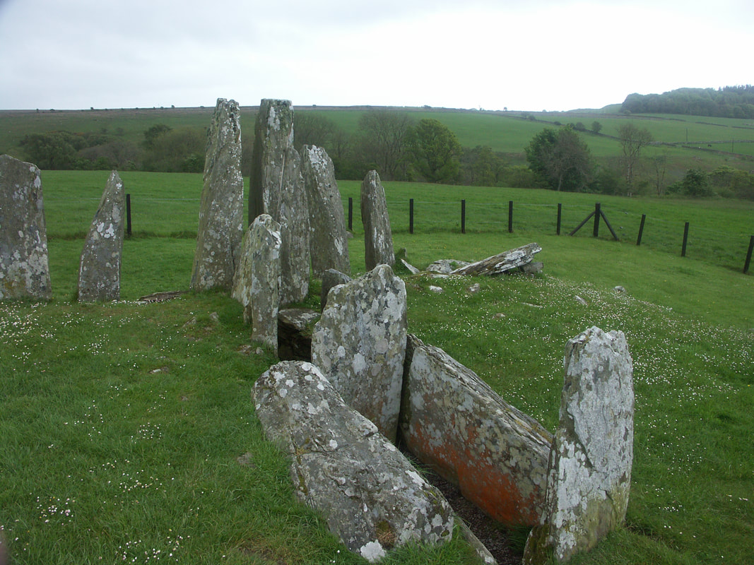
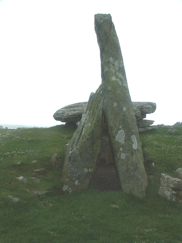
Nearest specialist whisky shops: AD Rattray Whisky Experience, Kirkoswald (37 miles); TB Watson, Dumfries (44 miles) and Robbie's Drams, Ayr (43 miles) NearbyCairnholy is a neolithic site with two impressive stone monuments between Creetown and Gatehouse of Fleet. Cairnholy I consists of 8 vertical stones, the largest two forming an entrance to the chamber with two compartments, the inner of which is believed to be the tomb. It was considerably larger, and smaller stones appear to have been removed for use in subsequent walls. Megalithic Portal
Cairnholy II is a chambered cairn 150 yards beyond Cairnholy I. The entrance is again reached through two large upright stones. The inner chamber is sealed by an upright stone and is roofed by a large precariously balanced capstone. again there has been much depredation over the millennia. Both are believed to date from between 4000 to 6000 years ago. Cairnholy Joe and the Stones The Megalithic Portal site also has links to other cup and ring marked stones in the area. Glenquicken stone circle, aka Billy Diamond's Bridge stone circle, two miles east of Creetown, just off the Old Military Road, and about 3 miles north of Cairnholy has 29 stones with a central stone. There were two more stone circles to the north west, shown on the 1st edition OS map, but nothing appears to remain now - the area was planted with trees, though the latest Google Satellite view shows it's been cleared. The Torhousekie stones lie to the east of Wigtown and covered on that page. Carsluith Castle is on the coast a couple of miles south of Creetown alongside the A75. It dates from the 16th century and later had a history of being a refuge for Catholic priests. It's not been occupied since 1748. Next to the castle is Marrbury Smokehouse and Bistro (01671 820476). Undiscovered Scotland The village of Carsluith is about a mile north of the castle, but doesn't have much except for the Galloway Smokehouse (016571 820354) and Fisherman's Café (01671 820350). Though it is an opportunity to get off the A75, and there's a cycle path alongside the road from there to Creetown. Harmony B&B Carsluith 07919 651417 Creetown was an important point on the old pilgrims route to Whithorn, as there was a low tide ford and ferry from here to Wigtown. (just marked as Ferry on this 1782 map). It was also on the military road to Ireland. Until 1986 it was on the A75 as well, but a new route on a causeway over reclaimed marshland, constructed using granite quarried from nearby Kirkmabreck, brought relief to the village. The railway came close to Creetown as well, the station being just a mile north on the other side of the Moneypool Burn. Creetown is also home to the Gem Rock Museum. There's a Creetown website, but it says it was last updated 14th July 2007. The Ellangowan Hotel was the location for the interior of the Green Man pub in the 1973 film The Wicker Man. Undiscovered Scotland Cherrytrees B&B 59 St John's Street 01671 820229 Ellangowan Hotel St John's Street 01671 820201 Barholm Accommodation St John's Street 01671 820810 (also cycle hire & repair) The Laird's Inn 5 Castle Cary Lodge 01671 820361 Muirifad B&B Palnure 01671 820536 Kirkcowan ("Church of St Comhghain" or "Comgan", uncle of St Fillan) The name presumably refers to an ancient church in the area (Kirkcowan is shown with a church on this map from around 1640), the Old Parish Church is recorded as having been built in 1732, though only the east gable remains in an old churchyard, the current church at the other end of the village dates from 1843. Kirkcowan, which lies close to the confluence of the Tarf Water and the River Bladnoch, prospered in the 19th century due to the construction of two woollen mills on the Tarf Water near the village - Waulk Mill was established in the late 18th century, though what remains appears to date from the 1821 rebuild, the mill closed in 1950. Tarff Mill was built on the opposite bank of the river in 1880, but closed in 1925, only the octagonal chimney remains. Kirkcowan is south of both the old military road and the A75, (the Wikipedia page on the A75 states that Kirkcowan was the first village by-passed by the A75, but the current route was around long before classification in 1922 - 1920s/1850s maps), but was close to the railway, when it was in operation from 1861 to 1965, and had a station. kirkcowan.com - online newsletter and information kirkcowan.info - historical info on Kirkcowan - uses the slogan Kirkcowan - out of this world; and explains its origin Criaghlaw Arms Hotel 23 Main Street 01671 830203 (bike washing & storage) Glentrool Village is in the north if Dumfries and Galloway, on NCN 7. The nearby Glen Trool Visitor Centre calls itself the gateway to the Galloway Hills. The Glen itself stretches along the Water of Trool and Loch Trool, which is only a couple of miles from Loch Dee. The Battle of Glen Trool of 1307, a victory for Robert the Bruce, is commemorated by House O'Hill Hotel Bargrennan 01671 840243 RA 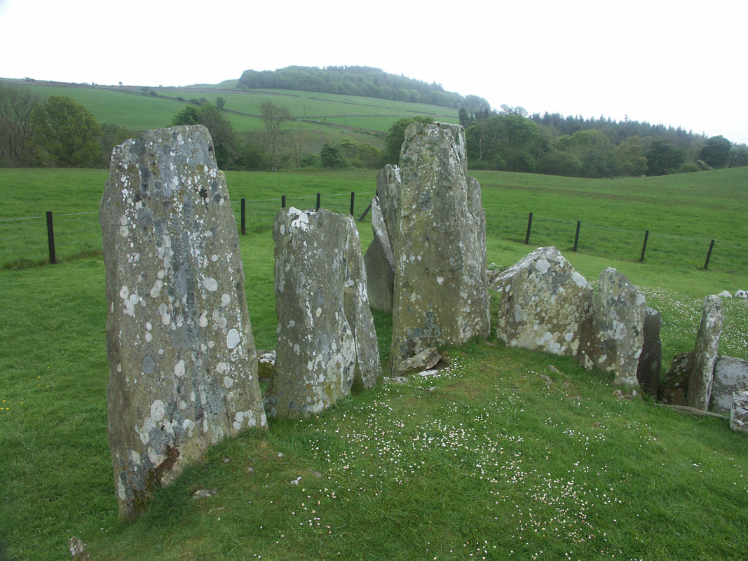
Cairnholy I
|
Newton Stewart was established by WIlliam Stewart, youngest son of the Earl of Galloway from around 1677. Though the lowest fording point of the River Cree, there was no large settlement here before then. The small village of Minnigaff still exists on the east of the River at the confluence with the Penklin Burn. The original ford was downstream from Minnigaff and replaced by a bridge in 1745, though this was washed away in 1806, a replacement built in 1813 still stands.
The Portpatrick Railway (Dumfries to Stranraer and Portpatrick), crossed the Cree about a mile south of Newton Stewart then it ran to a site west of the town where the station was located. Later the Whithorn Branch left the main line immediately after the station and ran parallel to the line into Newton Stewart for a mile. Arriving & DepartingOpen Cycle Map Bing Map
Newton Stewart is on National Cycle Route 7. Local cycle routes. See also newtonstewart.org Nearest stations - Barrhill (BRL) (18 miles) (Live Train Times) or Stranraer (STR) (25 miles) (Live Train Times) Bikes are carried on Stagecoach bus 500 from Dumfries to Stranraer, which passes through Newton Stewart. SleepingBlackhorse Hotel 66 Queen Street 01671 403302
Bruce Hotel 88 Queen Street 01671 402294 Creebridge House Hotel New Galloway Road 01671 402121 Creebridge Lodge B&B New Galloway Road 01671 402319 Crown Hotel 102 Queen Street 01671 402727 Flowerbank GH Millcroft Road, Minnigaff 01671 402629 Kiloran B&B Auchindoon Road 01671 401128 For other accommodation - see newtonstewart.org EatingBlackhorse Hotel 66 Queen Street 01671 403302
Bruce Hotel 88 Queen Street 01671 402294 Creebridge House Hotel New Galloway Road 01671 402121 Crown Hotel 102 Queen Street 01671 402727 Galloway Bar 54-58 Victoria Street 01671 404000 More Restaurants - newtonstewart.org DrinkingBlackhorse Hotel 66 Queen Street 01671 403302
Bruce Hotel 88 Queen Street 01671 402294 Creebridge House Hotel New Galloway Road 01671 402121 30 RA Crown Hotel 102 Queen Street 01671 402727 Galloway Bar 54-58 Victoria Street 01671 404000 RA For other Newton Stewart bars - see newtonstewart.org CyclingKirkcowan Cycles Old Red Cross Hall ,Victoria Lane 01671 401529
the break pad Kirroughtree Visitors Centre, Forest Drive, Palnure 01671 401303 (Not sure if the following shop is still there as their website is no longer working) HDI (Car Care) Ltd 80 Victoria Street 01671 404002 I remember this shop as I had split a tyre on some sharp stones on the edge of the road a couple of miles outside Newton Stewart in 2005 - doesn't show in search for Bike shops in Newton Stewart as bike hire/repairs etc is just one of a number of services provided by HDI.
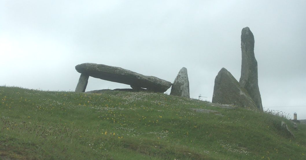
Cairnholy II
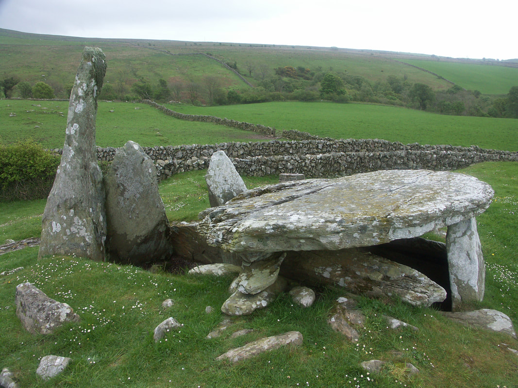
Cairnholy II
Cairnholy I
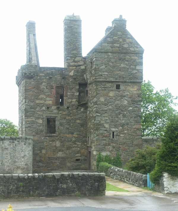
Carsluith Castle
|
Photos on this page were taken by me. Click on photo to enlarge. Full size versions and my other pictures of Kirkcudbright are available at: http://www.flickr.com/photos/martynjenkins/sets/72157628778498017
